Itinéraire raquette des Granges
in Vallorcine
Präsentation
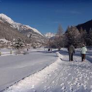
Vom Weiler Couteray, 1345m, führt eine breite Spur zwischen den typischen Holzbauten des "Vallée des Ours" hinauf. Die Spur verläuft im Zickzack durch den Wald, bevor sie in Les Granges 1566m mündet. Der Abstieg erfolgt bis zum Ort Sur le Rocher und dann zum Weiler Lay.
Höhenunterschied: 200m / Dauer: ca. 1 Stunde 20 Minuten
Der Zugang zum Pfad ist von den Wetterbedingungen abhängig. Für weitere Informationen wenden Sie sich bitte an das Office de Haute Montagne de Chamonix: +33 (0)4 50 53 22 08.
Entfernung
3.5km
Starthöhe
1345m
Positive Erhebung
200m
Negative Höhe
200m
Dauer der Hin- und Rückfahrt
1h20min
Preise
Freier Zugang.
Öffnungsdaten
Vom 17/12 bis 16/04 täglich.
Zugänglich je nach Wetterlage und außerhalb der Risikozeiten. Erkundigen Sie sich vorher bei der Touristeninformation nach den aktuellen Zugangsbedingungen.
Unter Vorbehalt günstiger Wetter- und Schneeverhältnisse.
Zugänglich je nach Wetterlage und außerhalb der Risikozeiten. Erkundigen Sie sich vorher bei der Touristeninformation nach den aktuellen Zugangsbedingungen.
Unter Vorbehalt günstiger Wetter- und Schneeverhältnisse.
Standort
Itinéraire raquette des Granges
Parking du Couteray
74660 Vallorcine
74660 Vallorcine


